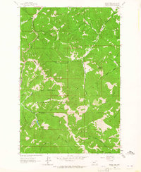
1963 Map of Rogers Pass
USGS Topo · Published 1964About this map
The Continental Divide carves a high path through this mountainous section of the Helena National Forest in the early 1960s. At the heart of the terrain lies Rogers Pass, where the landscape drops into the drainage basins of the Dearborn River and the Blackfoot River. The presence of the Mike Horse Mine near the headwaters of Anaconda Creek indicates the area's legacy of resource extraction, accompanied by a small reservoir noted with its Spillway Elev 5491.
Find a feature on this map
38 named features on this map. Tap any name to fly to it.
Don’t see what you’re looking for? This feature index may not catch every label — zoom into the map to look around manually.
Map Details
Editions of this 1963 Rogers Pass Map
2 editions found
Other maps of this area

1889 · Helena
USGS Topo · 1:250,000

1893 · Helena
USGS Topo · 1:250,000

1899 · Helena
USGS Topo · 1:250,000

1903 · Helena
USGS Topo · 1:250,000

1943 · Hogan
USGS Topo · 1:125,000

1947 · Butte
USGS Topo · 1:250,000

1955 · Choteau
USGS Topo · 1:250,000

1957 · Choteau
USGS Topo · 1:250,000

1958 · Butte
USGS Topo · 1:250,000

1958 · Choteau
USGS Topo · 1:250,000