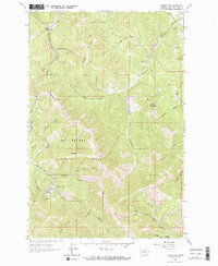
1963 Map of Rogers Pass
USGS Topo · Published 1964About this map
The Continental Divide bisects this 1963 survey, marking the dramatic crest where waters split between the Atlantic and Pacific watersheds. Located within the Helena National Forest, the landscape is defined by the high-elevation transition from the Blackfoot River drainage in the southwest to the headwaters of the Dearborn River and its South Fork Dearborn River in the north. Evidence of the region's mining history is anchored by the Mike Horse Mine near Anaconda Creek, while the remote character of the era is reflected in solitary landmarks like the Evergreen Cabin. Topographically prominent peaks such as Sunset Mountain and Denton Mountain overlook a complex network of gulches and creeks, including Wolf Creek and Lyons Creek, which served as vital corridors for early travel through Rogers Pass.
Find a feature on this map
33 named features on this map. Tap any name to fly to it.
Don’t see what you’re looking for? This feature index may not catch every label — zoom into the map to look around manually.
Map Details
Editions of this 1963 Rogers Pass Map
2 editions found
Other maps of this area

1889 · Helena
USGS Topo · 1:250,000

1893 · Helena
USGS Topo · 1:250,000

1899 · Helena
USGS Topo · 1:250,000

1903 · Helena
USGS Topo · 1:250,000

1943 · Hogan
USGS Topo · 1:125,000

1947 · Butte
USGS Topo · 1:250,000

1955 · Choteau
USGS Topo · 1:250,000

1957 · Choteau
USGS Topo · 1:250,000

1958 · Butte
USGS Topo · 1:250,000

1958 · Choteau
USGS Topo · 1:250,000