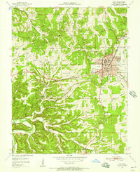
1951 Map of Rolla
USGS Topo · Published 1957About this map
The Missouri School of Mines serves as a central anchor for the city of Rolla, illustrating the town's growth as an educational and industrial hub in the mid-20th century. The St Louis San Francisco railroad corridor cuts through the landscape, linking the urban center to outlying communities like Doolittle and Northwye. This survey captures the region's diverse institutional history, from the specialized Missouri Trachoma Hospital to the rural school network including Strawhun Sch and Oak Grove Sch.
Find a feature on this map
57 named features on this map. Tap any name to fly to it.
Don’t see what you’re looking for? This feature index may not catch every label — zoom into the map to look around manually.
Map Details
Editions of this 1951 Rolla Map
3 editions found
Other maps of this area

1912 · Rolla
USGS Topo · 1:62,500

1928 · Meramec Spring
USGS Topo · 1:62,500

1934 · Redbird
USGS Topo · 1:62,500

1937 · Vienna
USGS Topo · 1:62,500

1938 · Redbird
USGS Topo · 1:62,500

1938 · Vienna
USGS Topo · 1:48,000

1949 · Saint Louis
USGS Topo · 1:250,000

1949 · Vienna
USGS Topo · 1:62,500

1949 · Rolla
USGS Topo · 1:250,000

1949 · Meramec Spring
USGS Topo · 1:62,500