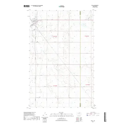
2017 Map of Rolla
USGS Topo · Published 2017About this map
Rolla serves as the primary hub of activity in this northern pocket of the Turtle Mountain region, organized around a traditional street grid including Main Ave E and Main Ave W. The landscape to the south and east transitions into a series of prairie wetlands and depressions, notably including the waters of McLaughlin Lake and the natural drainage of the Big Coulee. This 2017 survey by the U.S. Geological Survey captures the modern road network where local routes like Bia Rd 6 and Airport Rd connect the town to the surrounding agricultural sections. For those tracing family histories, the map identifies significant burial sites including Saint Michael Cem on the outskirts of town and the more isolated Emanuel Cem to the south, providing precise spatial context for these local landmarks.
Find a feature on this map
37 named features on this map. Tap any name to fly to it.
Don’t see what you’re looking for? This feature index may not catch every label — zoom into the map to look around manually.
Map Details
Editions of this 2017 Rolla Map
This is the sole edition of this map. No revisions or reprints were ever made.
Other maps of this area

1953 · Devils Lake
USGS Topo · 1:250,000

1956 · Devils Lake
USGS Topo · 1:250,000

1968 · Belcourt
USGS Topo · 1:24,000
1969 · Hansboro
USGS Topo · 1:24,000

1969 · Saint John
USGS Topo · 1:24,000

1969 · Rolla NE
USGS Topo · 1:24,000

1970 · Hansboro SW
USGS Topo · 1:24,000

1970 · Rolla
USGS Topo · 1:24,000

1971 · Mylo
USGS Topo · 1:24,000

1971 · Bisbee North
USGS Topo · 1:24,000