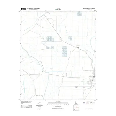
2012 Map of Rolling Fork West
USGS Topo · Published 2012About this map
Rolling Fork serves as the primary municipal center in this western Sharkey County landscape, where the town’s grid is defined by streets such as W China St, Parkway Ave, and S First St. The surrounding geography is characterized by an intricate network of waterways, including the winding Deer Cr and the artificial Steele Bayou Cutoff, reflecting the region’s long-standing focus on drainage and flood control in the Mississippi Delta. Agricultural patterns are evident through the numerous rectangular ponds and fields scattered near Booth and Lorenzen. Genealogists may find interest in the proximity of Elmwood Cem and Weathers Cem situated south of the main town. To the northwest, Grace and the Wade Airport mark the more rural sections of the quadrangle, while Poindexter Island sits near the confluence of major bayous and road networks like Lakeside Rd.
Find a feature on this map
46 named features on this map. Tap any name to fly to it.
Don’t see what you’re looking for? This feature index may not catch every label — zoom into the map to look around manually.
Map Details
Editions of this 2012 Rolling Fork West Map
This is the sole edition of this map. No revisions or reprints were ever made.
Other maps of this area

1909 · Wilsons Point
USGS Topo · 1:24,000

1913 · Wilson Point
USGS Topo · 1:31,680

1939 · Lorenzen
USGS Topo · 1:62,500

1939 · Readland
USGS Topo · 1:62,500

1939 · Mayersville
USGS Topo · 1:62,500

1939 · Swan Lake
USGS Topo · 1:62,500

1953 · Greenwood
USGS Topo · 1:250,000

1955 · Jackson
USGS Topo · 1:250,000

1956 · Greenwood
USGS Topo · 1:250,000

1961 · Jackson
USGS Topo · 1:250,000