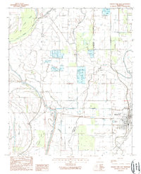
1988 Map of Rolling Fork West
USGS Topo · Published 1988About this map
The low-lying Mississippi Delta terrain of Issaquena and Sharkey counties defines this landscape, where the meandering course of Steele Bayou and its numerous tributaries like Tillman Bayou and Cross Bayou create a complex network of waterways. Agricultural adaptation is evident in the shift toward aquaculture, with extensive Fish Farms and specialized ponds appearing alongside traditional row-crop lands. The town of Rolling Fork serves as the primary eastern hub, situated along the Railroad Grade and Deer Creek.
Find a feature on this map
27 named features on this map. Tap any name to fly to it.
Don’t see what you’re looking for? This feature index may not catch every label — zoom into the map to look around manually.
Map Details
Editions of this 1988 Rolling Fork West Map
This is the sole edition of this map. No revisions or reprints were ever made.
Other maps of this area

1909 · Wilsons Point
USGS Topo · 1:24,000

1913 · Wilson Point
USGS Topo · 1:31,680

1939 · Lorenzen
USGS Topo · 1:62,500

1939 · Readland
USGS Topo · 1:62,500

1939 · Mayersville
USGS Topo · 1:62,500

1939 · Swan Lake
USGS Topo · 1:62,500

1953 · Greenwood
USGS Topo · 1:250,000

1955 · Jackson
USGS Topo · 1:250,000

1956 · Greenwood
USGS Topo · 1:250,000

1961 · Jackson
USGS Topo · 1:250,000