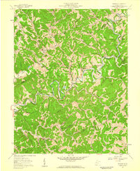
1957 Map of Romance
USGS Topo · Published 1959About this map
The Pocatalico River carves a winding path through the heart of Kanawha County, defining a landscape of deep hollows and high ridges that shaped the development of communities like Romance and Island Branch. This mid-century survey reveals a highly decentralized rural structure, where life centered on small, family-named landmarks and institutions. Numerous churches and schools are scattered across the terrain, including Pleasant Grove Ch and the Belle Sch, serving the residents of isolated valleys such as Davis Hollow and Parsons Hollow.
Find a feature on this map
84 named features on this map. Tap any name to fly to it.
Don’t see what you’re looking for? This feature index may not catch every label — zoom into the map to look around manually.
Map Details
Editions of this 1957 Romance Map
3 editions found
Other maps of this area

1897 · Kanawha Falls
USGS Topo · 1:125,000

1899 · Charleston
USGS Topo · 1:125,000

1900 · Kanawha Falls
USGS Topo · 1:125,000

1901 · Kanawha Falls
USGS Topo · 1:125,000

1906 · Kenna
USGS Topo · 1:62,500

1906 · Walton
USGS Topo · 1:62,500

1907 · Kenna
USGS Topo · 1:62,500

1907 · Walton
USGS Topo · 1:62,500

1907 · Clendenin
USGS Topo · 1:62,500

1909 · Charleston
USGS Topo · 1:62,500