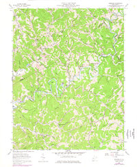
1957 Map of Romance
USGS Topo · Published 1977About this map
The Pocatalico River winds through the jagged ridges of Kanawha, Jackson, and Roane Counties, anchoring a rural landscape defined by narrow hollows and ridge-top homesteads in the mid-20th century. Named settlements like Romance and Advent are small but central to the community, often consisting of little more than a post office or a small cluster of homes at a crossroads. The economic reality of the era is visible in the network of oil wells and the prominent pipelines that cut across the topography, following the natural contours of Fisher Ridge and the steep drops into Opossum Hollow.
Find a feature on this map
95 named features on this map. Tap any name to fly to it.
Don’t see what you’re looking for? This feature index may not catch every label — zoom into the map to look around manually.
Map Details
Editions of this 1957 Romance Map
3 editions found
Other maps of this area

1897 · Kanawha Falls
USGS Topo · 1:125,000

1899 · Charleston
USGS Topo · 1:125,000

1900 · Kanawha Falls
USGS Topo · 1:125,000

1901 · Kanawha Falls
USGS Topo · 1:125,000

1906 · Kenna
USGS Topo · 1:62,500

1906 · Walton
USGS Topo · 1:62,500

1907 · Kenna
USGS Topo · 1:62,500

1907 · Walton
USGS Topo · 1:62,500

1907 · Clendenin
USGS Topo · 1:62,500

1909 · Charleston
USGS Topo · 1:62,500