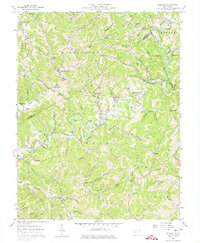
1957 Map of Romance
USGS Topo · Published 1974About this map
Romance and Cicerone anchor this section of West Virginia where the Poca River and Pocatalico River wind through the deeply dissected terrain of Kanawha, Roane, and Jackson Counties. The mid-century landscape is defined by small, stream-side communities and a dense network of family cemeteries such as the Wheatcraft Cem and Lanham Cem, reflecting generations of local settlement. Rural education and faith are central to the geography, evidenced by the many small schoolhouses and churches like Roosevelt Sch and Welcome Mission Ch. While the hills remain largely forested, the presence of numerous oil wells and gas wells particularly near Island Branch and Leatherwood indicates the area's industrial reliance on natural resource extraction during this era. High ridges like Fisher Ridge and Rockheap Ridge divide the numerous hollows and runs that feed into the larger river systems.
Find a feature on this map
86 named features on this map. Tap any name to fly to it.
Don’t see what you’re looking for? This feature index may not catch every label — zoom into the map to look around manually.
Map Details
Editions of this 1957 Romance Map
3 editions found
Other maps of this area

1897 · Kanawha Falls
USGS Topo · 1:125,000

1899 · Charleston
USGS Topo · 1:125,000

1900 · Kanawha Falls
USGS Topo · 1:125,000

1901 · Kanawha Falls
USGS Topo · 1:125,000

1906 · Kenna
USGS Topo · 1:62,500

1906 · Walton
USGS Topo · 1:62,500

1907 · Kenna
USGS Topo · 1:62,500

1907 · Walton
USGS Topo · 1:62,500

1907 · Clendenin
USGS Topo · 1:62,500

1909 · Charleston
USGS Topo · 1:62,500