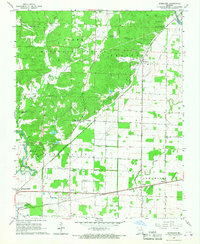
1966 Map of Rombauer
USGS Topo · Published 1967About this map
Clark National Forest dominates the northwestern portion of this Missouri landscape, where the Rombauer Lookout Tower stands watch over the hills of Ash Hill. The transition from the forested heights of Hoffman Hollow to the low-lying agricultural plains is marked by a network of drainage ditches and sloughs. This era shows a community deeply rooted in its local institutions, with numerous country churches and cemeteries such as New Bethany Ch and Stephenson Cem dotting the countryside. Transport and industry are defined by the convergence of the St Louis - San Francisco and Missouri Pacific railroads near the southern border, supporting the local economy alongside the Earl Fields Memorial Airport. The map also captures the path of the Black River and St Francis River as they move through the region, reflecting the water-dependent nature of the local settlements and industry.
Find a feature on this map
41 named features on this map. Tap any name to fly to it.
Don’t see what you’re looking for? This feature index may not catch every label — zoom into the map to look around manually.
Map Details
Editions of this 1966 Rombauer Map
2 editions found
Other maps of this area

1934 · Puxico
USGS Topo · 1:62,500

1935 · Poplar Bluff
USGS Topo · 1:62,500

1935 · Harviell
USGS Topo · 1:62,500

1939 · Puxico
USGS Topo · 1:62,500

1939 · Poplar Bluff
USGS Topo · 1:62,500

1940 · Valley Ridge
USGS Topo · 1:62,500

1949 · Poplar Bluff
USGS Topo · 1:62,500

1956 · Valley Ridge
USGS Topo · 1:62,500

1957 · Poplar Bluff
USGS Topo · 1:250,000

1959 · Poplar Bluff
USGS Topo · 1:250,000