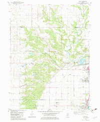
1982 Map of Rome
USGS Topo · Published 1983About this map
The Illinois River corridor in Peoria County is defined here by a transition from the agricultural uplands of La Prairie and Hallock to the industrial and residential developments near the riverbank. The Atchison Topeka and Santa Fe railroad skirts the base of the river bluffs, serving the growth of Rome and North Hampton. This era reflects a landscape where traditional community anchors, such as North Hampton Cem and Blue Ridge Ch, exist alongside modern infrastructure like the Illinois Valley Central High Sch and a series of large Gravel Pits. Local genealogy is well-supported by the presence of several established burial grounds, including La Salle Cem and Mooney Cem, which are situated near the southern edge of the survey. The drainage patterns of Senachwine Creek and Gilfillan Creek carve through the terrain, illustrating the natural geography that shaped the placement of early settlements and transport routes.
Find a feature on this map
30 named features on this map. Tap any name to fly to it.
Don’t see what you’re looking for? This feature index may not catch every label — zoom into the map to look around manually.
Map Details
Editions of this 1982 Rome Map
This is the sole edition of this map. No revisions or reprints were ever made.
Other maps of this area

1893 · Lacon
USGS Topo · 1:62,500

1893 · Metamora
USGS Topo · 1:62,500

1893 · Dunlap
USGS Topo · 1:62,500

1898 · Dunlap
USGS Topo · 1:62,500

1932 · Dunlap
USGS Topo · 1:62,500

1933 · Dunlap
USGS Topo · 1:62,500

1933 · Lacon
USGS Topo · 1:62,500

1933 · Camp Grove
USGS Topo · 1:48,000

1937 · Metamora
USGS Topo · 1:62,500

1937 · Dunlap
USGS Topo · 1:62,500