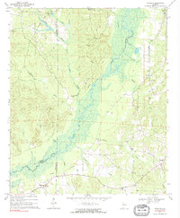
1970 Map of Romulus
USGS Topo · Published 1972About this map
The Sipsey River carves a winding path through this West Alabama landscape, defining the borders of Pickens, Greene, and Tuscaloosa Counties. Around 1970, the area remained largely rural, centered on small crossroads and family-named landmarks. The settlement of Buhl sits near the northern boundary, supported by the flow of Hammer Mill Creek and Caledonia Creek. Further south, the map documents the quiet communities of Jena and Romulus, where life was anchored by local congregations at Pleasant Grove Ch and New Hope Ch. A network of family histories is preserved in the location of Pate Cem and Caledonia Cem. Evidence of past industry and transport is visible in the Old Railroad Grade that cuts across the terrain, marking the path of former commerce long after the tracks themselves were gone.
Find a feature on this map
28 named features on this map. Tap any name to fly to it.
Don’t see what you’re looking for? This feature index may not catch every label — zoom into the map to look around manually.
Map Details
Editions of this 1970 Romulus Map
2 editions found
Other maps of this area

1924 · Tuscaloosa
USGS Topo · 1:62,500

1926 · Samantha
USGS Topo · 1:48,000

1926 · Tuscaloosa
USGS Topo · 1:62,500

1928 · Samantha
USGS Topo · 1:62,500

1953 · Birmingham
USGS Topo · 1:250,000

1956 · Birmingham
USGS Topo · 1:250,000

1957 · Birmingham
USGS Topo · 1:250,000

1967 · Gordo
USGS Topo · 1:24,000

1967 · Elrod
USGS Topo · 1:24,000
1969 · Fosters
USGS Topo · 1:24,000