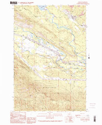
1989 Map of Ronald
USGS Topo · Published 1989About this map
Roslyn Cascade Mine No 4 and various mine dumps dominate the northeastern corner of this landscape, marking the coal mining history of the Ronald and Roslyn area. The industrial legacy of the Upper Kittitas Valley is clearly visible through these workings and a nearby Strip Mine, set against a complex network of water and transport. The Yakima River and Cle Elum River converge south of Cle Elum Lake, flanked by the John Wayne Pioneer State Park Trail which follows the path of former rail infrastructure. This 1980s data records the transition of the region, showing small settlements like Nelson and natural landmarks such as Lavender Lake and Domerie Flats that define the valley floor between Easton Ridge and South Elum Ridge.
Find a feature on this map
29 named features on this map. Tap any name to fly to it.
Don’t see what you’re looking for? This feature index may not catch every label — zoom into the map to look around manually.
Map Details
Editions of this 1989 Ronald Map
2 editions found
Other maps of this area

1897 · Mount Stuart
USGS Topo · 1:125,000

1901 · Snoqualmie Pass
USGS Topo · 1:125,000

1902 · Mount Stuart
USGS Topo · 1:125,000

1903 · Snoqualmie
USGS Topo · 1:125,000

1957 · Wenatchee
USGS Topo · 1:250,000

1958 · Cle Elum
USGS Topo · 1:62,500

1961 · Mount Stuart
USGS Topo · 1:62,500

1961 · Easton
USGS Topo · 1:62,500

1961 · Kachess Lake
USGS Topo · 1:62,500

1975 · Snoqualmie Pass
USGS Topo · 1:100,000