
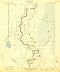
1915 Map of Ronda
USGS Topo · Published 1915About this map
The Sacramento River defines the landscape of this 1915 survey, winding through the Sutter Basin and forming a series of tight oxbows such as State Ranch Bend, Missouri Bend, and Eldorado Bend. This era of the Sacramento Valley was characterized by a transition from traditional river landings to rail-dominated logistics. The presence of Rough and Ready Landing on the riverbank stands in contrast to the Southern Pacific (Woodland Line) cutting diagonally across the plains toward the settlement of Ronda. Local history and archaeological interest are grounded in specific landmarks like the Indian Mound and the seasonal patterns of Sycamore Slough and Cache Creek, which reflect the complex hydrology of the region before modern intensive water management. The map also captures temporary work sites like Derby Camp tucked into a bend of the river.
Find a feature on this map
16 named features on this map. Tap any name to fly to it.
Don’t see what you’re looking for? This feature index may not catch every label — zoom into the map to look around manually.
Map Details
Editions of this 1915 Ronda Map
This is the sole edition of this map. No revisions or reprints were ever made.
Other maps of this area

1907 · Dunnigan
USGS Topo · 1:62,500

1907 · Woodland
USGS Topo · 1:62,500

1907 · Davisville
USGS Topo · 1:62,500

1910 · Knights Landing
USGS Topo · 1:31,680

1910 · Marcuse
USGS Topo · 1:31,680

1915 · Yolo
USGS Topo · 1:31,680
1915 · Kirkville
USGS Topo · 1:31,680

1916 · Grays Bend
USGS Topo · 1:31,680

1916 · Jacobs Corner
USGS Topo · 1:31,680

1916 · Hershey
USGS Topo · 1:31,680