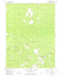
1980 Map of Roop Mountain
USGS Topo · Published 1980About this map
Lassen National Forest terrain dominates this 1980 study, characterized by high-elevation peaks and remote ranching outposts. The topographic detail captures the rugged transition from the heights of Roop Mountain and Goat Mountain down to the drainage basins of the Susan River and Willard Creek. Local land use is evident in the presence of the Willard Ranch and Bannel Ranch, along with scattered resource extraction sites like a Quarry and a Borrow Pit near the eastern boundary.
Find a feature on this map
25 named features on this map. Tap any name to fly to it.
Don’t see what you’re looking for? This feature index may not catch every label — zoom into the map to look around manually.
Map Details
Editions of this 1980 Roop Mountain Map
2 editions found
Other maps of this area

1886 · Honey Lake
USGS Topo · 1:250,000

1891 · Honey Lake
USGS Topo · 1:250,000

1893 · Honey Lake
USGS Topo · 1:250,000

1954 · Susanville
USGS Topo · 1:62,500

1954 · Fredonyer Peak
USGS Topo · 1:62,500

1955 · Westwood
USGS Topo · 1:62,500

1955 · Westwood
USGS Topo · 1:250,000

1956 · Antelope Mtn
USGS Topo · 1:62,500

1958 · Westwood
USGS Topo · 1:250,000

1959 · Westwood
USGS Topo · 1:250,000