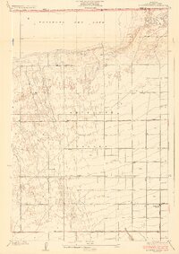
1933 Map of Roosevelt School
USGS Topo · Published 1933About this map
Antelope Valley dominates this 1930s landscape, illustrating a transition from open desert to a structured agricultural and educational district in Los Angeles County. The northern edge is defined by the expanse of Rosamond Dry Lake, while the southern reaches show a systematic grid of dirt roads and avenues cutting through the alluvial terrain. Centrally located, the Roosevelt School stands as a community focal point along Avenue H, surrounded by numerous individual water wells that indicate a reliance on groundwater for local homesteads. The terrain shows the characteristic drainage patterns of Little Rock Creek as it moves toward the dry lake bed. This survey captures a moment of early development where desert infrastructure, such as Redman Road and Muroc Road, began to formalize transportation across the High Desert before the rapid mid-century expansion of nearby aerospace facilities.
Find a feature on this map
19 named features on this map. Tap any name to fly to it.
Don’t see what you’re looking for? This feature index may not catch every label — zoom into the map to look around manually.
Map Details
Editions of this 1933 Roosevelt School Map
3 editions found

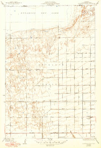
Other maps of this area

1915 · Elizabeth Lake
USGS Topo · 1:125,000

1917 · Elizabeth Lake
USGS Topo · 1:125,000

1930 · Oban
USGS Topo · 1:24,000

1930 · Roosevelt School
USGS Topo · 1:24,000

1930 · Casa Desierta
USGS Topo · 1:24,000

1930 · Lancaster
USGS Topo · 1:24,000

1930 · West Alpine Butte
USGS Topo · 1:24,000

1930 · Tierra Bonita
USGS Topo · 1:24,000

1933 · Lancaster
USGS Topo · 1:24,000

1933 · Casa Desierta
USGS Topo · 1:24,000