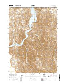
2017 Map of Rooster Comb
USGS Topo · Published 2017About this map
Lake Owyhee dominates this landscape in Malheur County, winding through the canyon system of eastern Oregon. The serpentine waterway is bounded by the sharp rise of Rooster Comb and the high elevations of Mahogany Mtn, which define the topography east of the reservoir. A network of drainages and springs, such as Shadscale Spring and Gin Spring, indicate the critical role of water management in this arid environment, further evidenced by the Gin Basin Reservoir located at Gin Basin. Settlement history is reflected in names like Schoolhouse Gulch and Dago Gulch, while the isolated Doe Island sits within the flooded canyon. The geography is characterized by dramatic shifts in elevation, from the flat expanse of Shadscale Flat to the plateaus of N Table Mtn and S Table Mtn.
Find a feature on this map
28 named features on this map. Tap any name to fly to it.
Don’t see what you’re looking for? This feature index may not catch every label — zoom into the map to look around manually.
Map Details
Editions of this 2017 Rooster Comb Map
This is the sole edition of this map. No revisions or reprints were ever made.
Other maps of this area

1955 · Boise
USGS Topo · 1:250,000

1958 · Boise
USGS Topo · 1:250,000

1962 · Boise
USGS Topo · 1:250,000

1967 · Pelican Point
USGS Topo · 1:24,000

1967 · Diamond Butte
USGS Topo · 1:24,000
1967 · Bannock Ridge
USGS Topo · 1:24,000

1967 · Rooster Comb
USGS Topo · 1:24,000

1967 · Quartz Mtn Basin
USGS Topo · 1:24,000
1967 · Three Fingers Rock
USGS Topo · 1:24,000
1969 · Mahogany Gap
USGS Topo · 1:24,000