
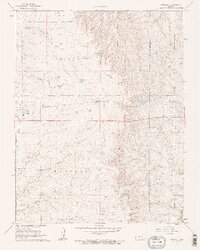
1961 Map of Rosalia
USGS Topo · Published 1962About this map
The Missouri Pacific railroad cuts a straight east-west line across this Kansas landscape, connecting the small settlements of Rosalia, Summit, and Sallyards. In the early 1960s, this region on the border of Butler and Greenwood counties was defined by a mix of agricultural pastureland and active petroleum extraction. The landscape is punctuated by the Jackson Oil Field, Sallyards Oil Field, and Stanhope Oil Field, reflecting the industrial importance of the area. A notable historical marker, the Old Indian Boundary, runs vertically through the center of the sheet, while the Blankinship Cem provides a point of interest for genealogists. Waterways like the Little Walnut River and Spring Creek wind through the terrain, with Windy Hill standing as a prominent local elevation near the eastern edge.
Find a feature on this map
27 named features on this map. Tap any name to fly to it.
Don’t see what you’re looking for? This feature index may not catch every label — zoom into the map to look around manually.
Map Details
Editions of this 1961 Rosalia Map
2 editions found
Other maps of this area

1885 · Eureka
USGS Topo · 1:125,000

1888 · Eureka
USGS Topo · 1:125,000

1888 · Eldorado
USGS Topo · 1:125,000

1894 · Eureka
USGS Topo · 1:125,000

1955 · Wichita
USGS Topo · 1:250,000

1958 · Wichita
USGS Topo · 1:250,000

1961 · Pontiac
USGS Topo · 1:24,000

1961 · Rosalia NE
USGS Topo · 1:24,000
1961 · Rosalia NW
USGS Topo · 1:24,000

1964 · Piedmont NW
USGS Topo · 1:24,000