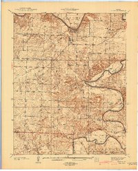
1940 Map of Roscoe
USGS Topo · Published 1940About this map
The confluence of the Osage River and the Sac River shapes the geography of this 1940 preliminary edition, which captures the river-bottom lands of St. Clair and Cedar counties before major later-century inundations. The settlement of Roscoe serves as a central hub, flanked by the elevated Osage Heights and the rocky outcrops of Rockhouse Cave and Keeton Cave. The map documents a landscape defined by small-scale agrarian communities and rural education, evidenced by the distribution of several local schools such as Virginia Sch and Riverview Sch.
Find a feature on this map
53 named features on this map. Tap any name to fly to it.
Don’t see what you’re looking for? This feature index may not catch every label — zoom into the map to look around manually.
Map Details
Editions of this 1940 Roscoe Map
2 editions found

Other maps of this area

1886 · Stockton
USGS Topo · 1:125,000

1887 · Clinton
USGS Topo · 1:125,000

1894 · Clinton
USGS Topo · 1:125,000

1937 · Tiffin
USGS Topo · 1:31,680

1938 · Monegaw Springs
USGS Topo · 1:24,000

1938 · Roscoe
USGS Topo · 1:24,000

1938 · Vista
USGS Topo · 1:24,000

1938 · Taberville
USGS Topo · 1:24,000

1939 · Caplinger Mills
USGS Topo · 1:24,000

1939 · Osceola
USGS Topo · 1:24,000