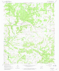
1963 Map of Rose Bud
USGS Topo · Published 1981About this map
Rose Bud serves as the central hub for this rural Arkansas landscape, situated where several state highways intersect north of the Faulkner and White County lines. The area is defined by its numerous small community centers and country houses of worship, including St Marys Ch, Plants Chapel, and Mt Bethel Ch. The terrain is characterized by a series of prominent elevations like Cadron Mountain and Starkey Mountain, while the hydrology is dominated by the winding path of the East Fork Cadron Creek. Local industry and land use are evidenced by various Quarries and a Quarry near Cadron Creek. Genealogists will find significant value in the documentation of family and community burial grounds such as Moon Cem, Starkey Cem, and the Rose Bud Cem, providing a detailed record of local family names and settlement patterns during the early 1960s.
Find a feature on this map
52 named features on this map. Tap any name to fly to it.
Don’t see what you’re looking for? This feature index may not catch every label — zoom into the map to look around manually.
Map Details
Editions of this 1963 Rose Bud Map
2 editions found
Other maps of this area

1953 · Memphis
USGS Topo · 1:250,000

1956 · Memphis
USGS Topo · 1:250,000

1956 · Russellville
USGS Topo · 1:250,000

1963 · Rose Bud
USGS Topo · 1:24,000

1963 · Floyd
USGS Topo · 1:24,000

1963 · Quitman
USGS Topo · 1:24,000

1963 · West Pangburn
USGS Topo · 1:24,000

1963 · Enola
USGS Topo · 1:24,000

1963 · Mount Vernon
USGS Topo · 1:24,000

1963 · Sidon
USGS Topo · 1:24,000