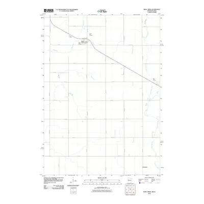
2010 Map of Rose Creek
USGS Topo · Published 2010About this map
Rose Creek serves as the primary hub in this southern Minnesota landscape, where the local economy and social life are anchored by the Rose Creek Post Office and several rural burial grounds. The map reveals a strictly gridded agricultural layout, defined by roads such as 610th Ave and 170th St, which navigate the gentle drainage basins of Otter Creek and the Little Cedar River. For genealogists, the proximity of Saint Peter Cemetery and Prairie View Cemetery near the main township offers a clear view of the area's early settlement clusters. Further south, the small community of Johnsburg sits along the meandering banks of the Little Cedar River, illustrating the traditional pattern of village development along regional waterways before reaching the Iowa border.
Find a feature on this map
28 named features on this map. Tap any name to fly to it.
Don’t see what you’re looking for? This feature index may not catch every label — zoom into the map to look around manually.
Map Details
Editions of this 2010 Rose Creek Map
This is the sole edition of this map. No revisions or reprints were ever made.
Other maps of this area

1954 · Austin
USGS Topo · 1:62,500

1954 · Mason City
USGS Topo · 1:250,000

1957 · Mason City
USGS Topo · 1:250,000

1958 · Mason City
USGS Topo · 1:250,000

1965 · Dexter
USGS Topo · 1:24,000

1965 · Adams
USGS Topo · 1:24,000

1972 · St. Ansgar
USGS Topo · 1:24,000

1972 · Little Cedar
USGS Topo · 1:24,000
1972 · Stacyville
USGS Topo · 1:24,000
1982 · Austin East
USGS Topo · 1:24,000