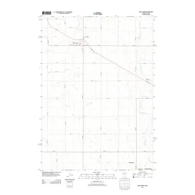
2013 Map of Rose Creek
USGS Topo · Published 2013About this map
Rose Creek serves as the primary hub of this Mower County landscape, situated at the intersection of MN-56 and Co HWY-4. The area is defined by a grid of agricultural section roads and the winding paths of several waterways, including the Little Cedar River, Otter Cr, and its namesake Rose Cr. This 2013 survey provides essential details for genealogists, documenting multiple local burial grounds such as Saint Peter Cem, Prairie View Cem, and the Little Cedar Cem located to the east. Further south, the small settlement of Johnsburg anchors the lower portion of the map, illustrating the enduring layout of rural southern Minnesota. The presence of a local Po and named streets like Maple St SE within the main town center highlights the community's established infrastructure.
Find a feature on this map
31 named features on this map. Tap any name to fly to it.
Don’t see what you’re looking for? This feature index may not catch every label — zoom into the map to look around manually.
Map Details
Editions of this 2013 Rose Creek Map
This is the sole edition of this map. No revisions or reprints were ever made.
Other maps of this area

1954 · Austin
USGS Topo · 1:62,500

1954 · Mason City
USGS Topo · 1:250,000

1957 · Mason City
USGS Topo · 1:250,000

1958 · Mason City
USGS Topo · 1:250,000

1965 · Dexter
USGS Topo · 1:24,000

1965 · Adams
USGS Topo · 1:24,000

1972 · St. Ansgar
USGS Topo · 1:24,000

1972 · Little Cedar
USGS Topo · 1:24,000
1972 · Stacyville
USGS Topo · 1:24,000
1982 · Austin East
USGS Topo · 1:24,000