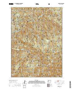
2020 Map of Rose Hill
USGS Topo · Published 2020About this map
The Umpqua National Forest defines this landscape in Lane County, where the topography is marked by significant drainages and high ridges. The area is anchored by the namesake Rose Hill and Sugarloaf Mtn, with the watershed of Brice Creek and its many tributaries, such as Laying Cr and Crawfish Cr, carving deep valleys through the terrain. Evidence of historical access and mountain commerce appears in the 4wd Noonday Wagon Road and the Marten Flume, indicating the region's legacy of timber and transport.
Find a feature on this map
54 named features on this map. Tap any name to fly to it.
Don’t see what you’re looking for? This feature index may not catch every label — zoom into the map to look around manually.
Map Details
Editions of this 2020 Rose Hill Map
This is the sole edition of this map. No revisions or reprints were ever made.
Other maps of this area

1935 · Lowell
USGS Topo · 1:96,000

1942 · Lowell
USGS Topo · 1:125,000

1955 · Hardesty Mtn
USGS Topo · 1:62,500

1955 · Fairview Peak
USGS Topo · 1:62,500

1955 · Culp Creek
USGS Topo · 1:62,500

1955 · Lowell
USGS Topo · 1:62,500

1958 · Roseburg
USGS Topo · 1:250,000

1959 · Roseburg
USGS Topo · 1:250,000

1983 · Oakridge
USGS Topo · 1:100,000
1986 · Mount June
USGS Topo · 1:24,000