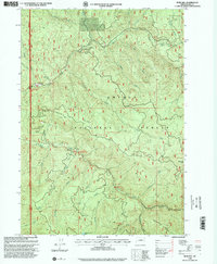
1998 Map of Rose Hill
USGS Topo · Published 2000About this map
Laying Creek Fossil Beds and the surrounding watersheds of the Umpqua National Forest define this landscape on the border of Lane and Douglas counties. The terrain is characterized by steep ridges and a dense network of drainages, including the prominent Dinner Ridge and the heights of Sugarloaf Mtn. Numerous quarries are scattered throughout the hills, reflecting the active resource management and road maintenance within the forest during the late 20th century.
Find a feature on this map
45 named features on this map. Tap any name to fly to it.
Don’t see what you’re looking for? This feature index may not catch every label — zoom into the map to look around manually.
Map Details
Editions of this 1998 Rose Hill Map
This is the sole edition of this map. No revisions or reprints were ever made.
Other maps of this area

1935 · Lowell
USGS Topo · 1:96,000

1942 · Lowell
USGS Topo · 1:125,000

1955 · Hardesty Mtn
USGS Topo · 1:62,500

1955 · Fairview Peak
USGS Topo · 1:62,500

1955 · Culp Creek
USGS Topo · 1:62,500

1955 · Lowell
USGS Topo · 1:62,500

1958 · Roseburg
USGS Topo · 1:250,000

1959 · Roseburg
USGS Topo · 1:250,000

1983 · Oakridge
USGS Topo · 1:100,000
1986 · Mount June
USGS Topo · 1:24,000