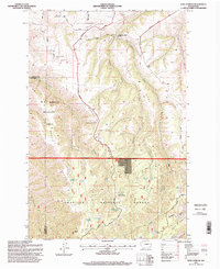
1995 Map of Rose Springs
USGS Topo · Published 1998About this map
Tatman Mountain and Calloway Hill anchor the northern reaches of this landscape, where the high ridges of Garfield and Columbia counties drop toward Pataha Creek. In the mid-1990s, the terrain was defined by significant conservation and forest management zones, including the W T Wooten Wildlife Area and the Umatilla National Forest. A high concentration of named springs, such as Rose Springs, Lanzie Spring, and Alder Thicket Spring, suggests a landscape where water sources were critical for the early range and timber activities that shaped the region. Near the small settlement of Columbia Center, historical routes like Bosley Grade and Linville Road follow the natural contours of the steep canyons. This geography, from the broad Grouse Flat to the deep Sweeney Gulch, illustrates the complex topography that hindered easy transit but supported a specialized mountain economy.
Find a feature on this map
42 named features on this map. Tap any name to fly to it.
Don’t see what you’re looking for? This feature index may not catch every label — zoom into the map to look around manually.
Map Details
Editions of this 1995 Rose Springs Map
This is the sole edition of this map. No revisions or reprints were ever made.
Other maps of this area

1937 · Pomeroy
USGS Topo · 1:96,000

1942 · Pomeroy
USGS Topo · 1:125,000

1943 · Peola
USGS Topo · 1:62,500

1943 · Saddle Butte
USGS Topo · 1:62,500

1946 · Saddle Butte
USGS Topo · 1:62,500

1946 · Peola
USGS Topo · 1:62,500

1955 · Pullman
USGS Topo · 1:250,000

1958 · Pullman
USGS Topo · 1:250,000

1967 · Rose Springs
USGS Topo · 1:24,000

1967 · Hopkins Ridge
USGS Topo · 1:24,000