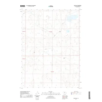
2017 Map of Rose Valley
USGS Topo · Published 2017About this map
Rose Valley sits within the undulating Nebraska Sandhills, serving as a focal point in a landscape defined by seasonal water and rolling terrain. The area is characterized by the presence of Swan Lake and Conway Lake, which contrast with the surrounding prairie. This 2017 survey reveals the intricate topography of the Calf Creek Valley, where the intermittent flow of Calf Cr winds through the hills. Human intervention is evidenced by the established sections of Dry Valley Rd and Seneca Rd, which navigate the contours of the land. The presence of Giant Hill provides a distinct local landmark, while the road network including Giant Hill Ln suggests a sparse but deliberate settlement pattern typical of the Cherry County cattle country. The map illustrates how ranching life adapts to the natural geography of the plains, preserving a specific ranch-country layout into the modern era.
Find a feature on this map
13 named features on this map. Tap any name to fly to it.
Don’t see what you’re looking for? This feature index may not catch every label — zoom into the map to look around manually.
Map Details
Editions of this 2017 Rose Valley Map
This is the sole edition of this map. No revisions or reprints were ever made.
Other maps of this area

1948 · Seneca
USGS Topo · 1:62,500

1948 · Seneca 4
USGS Topo · 1:62,500

1949 · Seneca 4
USGS Topo · 1:62,500

1951 · Seneca
USGS Topo · 1:62,500

1951 · Bull Lake
USGS Topo · 1:62,500

1951 · Brownlee
USGS Topo · 1:62,500

1957 · Valentine
USGS Topo · 1:250,000

1959 · Valentine
USGS Topo · 1:250,000

1985 · Goose Creek
USGS Topo · 1:100,000
1985 · Brownlee Flats
USGS Topo · 1:24,000