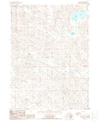
1987 Map of Rose Valley
USGS Topo · Published 1988About this map
Isolated ranches define the high plains of Cherry County in this mid-1980s provisional survey. The landscape is dominated by the intricate topography of the Nebraska Sandhills, where family operations like the Simonson and Lowe Ranch and the Jim Miller Ranch manage vast grazing lands. The hydrology of the region is centered on natural depressions that form bodies of water such as Swan Lake and Conway Lake, which provide essential resources in an otherwise semi-arid environment. Low-lying corridors like Rose Valley and Calf Creek Valley dictate the placement of unimproved roads and property boundaries, tracing the natural contours of the land. Landmarks such as Giant Hill rise above the surrounding dunes, serving as orientation points for local ranchers and land managers navigating the expansive, open terrain between Calf Creek and the surrounding basins.
Find a feature on this map
14 named features on this map. Tap any name to fly to it.
Don’t see what you’re looking for? This feature index may not catch every label — zoom into the map to look around manually.
Map Details
Editions of this 1987 Rose Valley Map
This is the sole edition of this map. No revisions or reprints were ever made.
Other maps of this area

1948 · Seneca
USGS Topo · 1:62,500

1948 · Seneca 4
USGS Topo · 1:62,500

1949 · Seneca 4
USGS Topo · 1:62,500

1951 · Seneca
USGS Topo · 1:62,500

1951 · Bull Lake
USGS Topo · 1:62,500

1951 · Brownlee
USGS Topo · 1:62,500

1957 · Valentine
USGS Topo · 1:250,000

1959 · Valentine
USGS Topo · 1:250,000

1985 · Goose Creek
USGS Topo · 1:100,000
1985 · Brownlee Flats
USGS Topo · 1:24,000