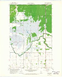
1966 Map of Roseau NE
USGS Topo · Published 1968About this map
The Roseau River meanders through the township of Jadis, marking a landscape defined by the drainage patterns of northern Minnesota. This mid-1960s survey captures the area as it borders the Canada United States international boundary, where the Port of Entry U. S. Customs stands as a focal point for cross-border transit near the junction of Sprague Creek. The presence of a vast area labeled Lakebed suggests the significant glacial history and subsequent agricultural reclamation efforts in this corner of Roseau County.
Find a feature on this map
13 named features on this map. Tap any name to fly to it.
Don’t see what you’re looking for? This feature index may not catch every label — zoom into the map to look around manually.
Map Details
Editions of this 1966 Roseau NE Map
2 editions found
Other maps of this area

1918 · Goos
USGS Topo · 1:62,500

1918 · Roseau
USGS Topo · 1:62,500

1943 · Goos
USGS Topo · 1:62,500

1954 · Roseau
USGS Topo · 1:250,000

1957 · Roseau
USGS Topo · 1:250,000

1958 · Roseau
USGS Topo · 1:250,000

1963 · Kenora
USGS Topo · 1:250,000
1966 · Pinecreek
USGS Topo · 1:24,000
1966 · Fox
USGS Topo · 1:24,000

1966 · Salol NW
USGS Topo · 1:24,000