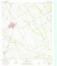
1962 Map of Rosebud
USGS Topo · Published 1978About this map
Rosebud serves as the focal point of this Central Texas landscape, situated along the Southern Pacific rail line and the intersection of Highway 77 and Loop 265. The map reveals a community defined by its civic and educational infrastructure, including Wilson White High Sch, Panther Field, and a local Hospital. To the south, the settlement of Burlington is marked by a concentration of religious and memorial sites such as St Michaels Cem, Burlington Cem, and St Anne Ch.
Find a feature on this map
39 named features on this map. Tap any name to fly to it.
Don’t see what you’re looking for? This feature index may not catch every label — zoom into the map to look around manually.
Map Details
Editions of this 1962 Rosebud Map
2 editions found
Other maps of this area

1885 · Taylor
USGS Topo · 1:125,000

1887 · Taylor
USGS Topo · 1:125,000

1892 · Temple
USGS Topo · 1:125,000

1894 · Taylor
USGS Topo · 1:125,000

1954 · Waco
USGS Topo · 1:250,000

1954 · Austin
USGS Topo · 1:250,000

1955 · Waco
USGS Topo · 1:250,000

1961 · Baileyville
USGS Topo · 1:24,000

1962 · Maysfield
USGS Topo · 1:24,000

1962 · Rosebud
USGS Topo · 1:24,000