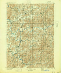
1900 Map of Roseburg
USGS Topo · Published 1930About this map
The North Umpqua and South Umpqua River converge northwest of Roseburg, forming a landscape defined by the winding Umpqua River and its fertile valleys. This 1890s survey, reprinted in 1930, captures the central corridor of Douglas County when the Southern Pacific railroad served as the primary transit artery, connecting settlements like Wilbur, Sutherlin, and Oakland. The map reveals a mosaic of distinct valley communities, including Garden Valley, Lookingglass Valley, and Happy Valley, each situated amidst significant terrain features like Dodson Mt and Richards Butte.
Find a feature on this map
63 named features on this map. Tap any name to fly to it.
Don’t see what you’re looking for? This feature index may not catch every label — zoom into the map to look around manually.
Map Details
Editions of this 1900 Roseburg Map
5 editions found
Other maps of this area

1891 · Ashland
USGS Topo · 1:250,000

1893 · Ashland
USGS Topo · 1:250,000

1897 · Roseburg
USGS Topo · 1:125,000

1897 · Ashland
USGS Topo · 1:250,000

1900 · Roseburg
USGS Topo · 1:125,000

1904 · Riddle
USGS Topo · 1:125,000

1928 · Sitkum
USGS Topo · 1:125,000

1935 · Lowell
USGS Topo · 1:96,000

1942 · Lowell
USGS Topo · 1:125,000

1944 · Tiller
USGS Topo · 1:62,500