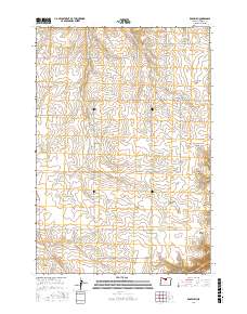
2017 Map of Rosebush
USGS Topo · Published 2017About this map
Rosebush and Rutledge anchor this portion of Sherman County, where the high plateau is deeply dissected by a network of drainage canyons. This landscape is defined by its water sources and topography, featuring reliable points like Middle Spring, South Spring, and Hill Spring that supported local ranching and settlement operations. The drainage patterns are clearly marked by Rosebush Cr and Finnegan Cr, which feed into steep-walled geographic features such as Little Ferry Canyon and Rosebush Canyon. A robust grid of local roads and lanes, including Bourbon Ln, Rutledge Rd, and Smith Todd Rd, reveals the enduring agricultural and residential footprint across the townships of T2S, T3S, and T4S. To the south, Berstel Pond provides a rare surface water landmark in this arid, high-elevation environment.
Find a feature on this map
32 named features on this map. Tap any name to fly to it.
Don’t see what you’re looking for? This feature index may not catch every label — zoom into the map to look around manually.
Map Details
Editions of this 2017 Rosebush Map
This is the sole edition of this map. No revisions or reprints were ever made.
Other maps of this area

1953 · The Dalles
USGS Topo · 1:250,000

1956 · The Dalles
USGS Topo · 1:250,000

1957 · The Dalles
USGS Topo · 1:250,000

1962 · Erskine
USGS Topo · 1:24,000

1962 · Grass Valley
USGS Topo · 1:24,000

1970 · Indian Cove
USGS Topo · 1:24,000

1970 · Kent
USGS Topo · 1:24,000

1970 · Rosebush
USGS Topo · 1:24,000

1971 · Moro
USGS Topo · 1:24,000
1971 · Horseshoe Bend
USGS Topo · 1:24,000