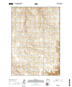
2020 Map of Rosebush
USGS Topo · Published 2020About this map
Rutledge and the namesake settlement of Rosebush anchor this portion of Sherman County, where the high plateau is deeply incised by a series of dramatic canyons. This landscape is defined by the drainage patterns of Rosebush Cr and Finnegan Cr, which feed into steep-walled geological features like Little Ferry Canyon and Dunlap Canyon. The distribution of natural water sources, including Middle Spring, South Spring, and Hill Spring, highlights the critical importance of reliable water in this arid environment.
Find a feature on this map
33 named features on this map. Tap any name to fly to it.
Don’t see what you’re looking for? This feature index may not catch every label — zoom into the map to look around manually.
Map Details
Editions of this 2020 Rosebush Map
This is the sole edition of this map. No revisions or reprints were ever made.
Other maps of this area

1953 · The Dalles
USGS Topo · 1:250,000

1956 · The Dalles
USGS Topo · 1:250,000

1957 · The Dalles
USGS Topo · 1:250,000

1962 · Erskine
USGS Topo · 1:24,000

1962 · Grass Valley
USGS Topo · 1:24,000

1970 · Indian Cove
USGS Topo · 1:24,000

1970 · Kent
USGS Topo · 1:24,000

1970 · Rosebush
USGS Topo · 1:24,000

1971 · Moro
USGS Topo · 1:24,000
1971 · Horseshoe Bend
USGS Topo · 1:24,000