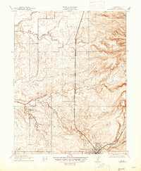
1910 Map of Roseville
USGS Topo · Published 1947About this map
The town of Roseville serves as the focal point of this 1910 survey, showing the community just as it was becoming a major railroad hub. The Southern Pacific tracks run through the center of town, with the Marysville Line striking north toward the settlement of Whitney. This period map captures the early 20th-century landscape of Placer County before suburban expansion, defined by its intricate drainage systems including Pleasant Grove Creek, Auburn Ravine, and Miners Ravine. To the west, the rural character of the land is anchored by the Pleasant Grove School, located near the confluence of the South Branch Pleasant Grove Creek. The topography reveals the gradual rise into the Sierra Nevada foothills, where a lone Reservoir and the winding course of Rock Creek mark the higher ground to the north.
Find a feature on this map
13 named features on this map. Tap any name to fly to it.
Don’t see what you’re looking for? This feature index may not catch every label — zoom into the map to look around manually.
Map Details
Editions of this 1910 Roseville Map
2 editions found
Other maps of this area

1891 · Sacramento
USGS Topo · 1:125,000

1892 · Sacramento
USGS Topo · 1:125,000

1893 · Sacramento
USGS Topo · 1:125,000

1902 · Fairoaks
USGS Topo · 1:62,500

1910 · Sheridan
USGS Topo · 1:31,680

1910 · Lincoln
USGS Topo · 1:31,680

1910 · Roseville
USGS Topo · 1:31,680

1910 · Pleasant Grove
USGS Topo · 1:31,680

1911 · Arcade
USGS Topo · 1:31,680

1911 · Antelope
USGS Topo · 1:31,680