
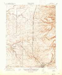
1910 Map of Roseville
USGS Topo · Published 1910About this map
The railroad junction at Roseville serves as the focal point of this 1908 survey, capturing the town's early growth where the Southern Pacific tracks split toward Marysville and Ogden. The landscape to the north and west is defined by a dense network of watercourses, including Pleasant Grove Creek and Rock Creek, which drain the low-lying hills. This area represents a transition from the developing rail hub into a more rural agricultural district, evidenced by landmarks like the Pleasant Grove School and the Kaseberg property.
Find a feature on this map
16 named features on this map. Tap any name to fly to it.
Don’t see what you’re looking for? This feature index may not catch every label — zoom into the map to look around manually.
Map Details
Editions of this 1910 Roseville Map
2 editions found
Other maps of this area

1891 · Sacramento
USGS Topo · 1:125,000

1892 · Sacramento
USGS Topo · 1:125,000

1893 · Sacramento
USGS Topo · 1:125,000

1902 · Fairoaks
USGS Topo · 1:62,500

1910 · Sheridan
USGS Topo · 1:31,680

1910 · Lincoln
USGS Topo · 1:31,680

1910 · Pleasant Grove
USGS Topo · 1:31,680

1911 · Arcade
USGS Topo · 1:31,680

1911 · Antelope
USGS Topo · 1:31,680

1914 · Folsom
USGS Topo · 1:31,680