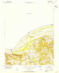
1954 Map of Rosiclare
USGS Topo · Published 1955About this map
The Ohio River forms the central artery of this 1954 survey, defining the border between Kentucky and Illinois. The landscape is dominated by the river's influence, seen clearly in the large Hurricane Island and the complex of backwaters like Mud Lake and Barnett Lake that follow the shoreline. This era of the river's history is marked by the presence of the Elizabethtown Ferry, providing a vital transit link between the two states before modern bridges became common.
Find a feature on this map
24 named features on this map. Tap any name to fly to it.
Don’t see what you’re looking for? This feature index may not catch every label — zoom into the map to look around manually.
Map Details
Editions of this 1954 Rosiclare Map
This is the sole edition of this map. No revisions or reprints were ever made.
Other maps of this area

1916 · Shawneetown
USGS Topo · 1:62,500

1916 · Fords Ferry
USGS Topo · 1:62,500

1916 · Golconda
USGS Topo · 1:62,500

1916 · Equality
USGS Topo · 1:62,500

1920 · Goloonda
USGS Topo · 1:48,000

1921 · Fords Ferry
USGS Topo · 1:48,000

1921 · Golconda
USGS Topo · 1:62,500

1925 · Cave In Rock
USGS Topo · 1:62,500

1949 · Paducah
USGS Topo · 1:250,000

1950 · Paducah
USGS Topo · 1:250,000