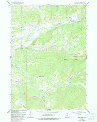
1965 Map of Rosies Ridge
USGS Topo · Published 1991About this map
Buffalo Fork snakes through this high-altitude landscape of the Teton National Forest and Teton Wilderness, defining a region shaped by wilderness recreation and forestry management in the mid-1960s. The presence of the Blackrock Ranger Station and various seasonal facilities like the Turpin Meadow Lodge and Hatchet Campground reflects the area's role as a gateway for backcountry exploration. High ridges and peaks such as Rosies Ridge and Baldy Mountain overlook a complex drainage system including Blackrock Creek and Spread Creek. This survey captures the infrastructure of the day, from the Pack Trail networks near Turpin Meadow to the Radio Tower on the ridge, providing a look at land use before modern changes. For genealogists and local historians, the specific locations of the Fourmile Meadow Picnic Area and named flats like Sagebrush Flat offer precise points for tracing historical movement through these mountains.
Find a feature on this map
28 named features on this map. Tap any name to fly to it.
Don’t see what you’re looking for? This feature index may not catch every label — zoom into the map to look around manually.
Map Details
Editions of this 1965 Rosies Ridge Map
2 editions found
Other maps of this area

1902 · Mt Leidy
USGS Topo · 1:125,000

1955 · Driggs
USGS Topo · 1:250,000

1958 · Driggs
USGS Topo · 1:250,000

1962 · Driggs
USGS Topo · 1:250,000

1965 · Davis Hill
USGS Topo · 1:24,000

1965 · Green Mountain
USGS Topo · 1:24,000

1965 · Rosies Ridge
USGS Topo · 1:24,000

1965 · Mount Leidy
USGS Topo · 1:24,000

1965 · Tripod Peak
USGS Topo · 1:24,000
1965 · Whetstone Mountain
USGS Topo · 1:24,000