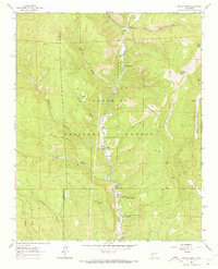
1961 Map of Rosilla Peak
USGS Topo · Published 1973About this map
The Pecos River valley carves through the Santa Fe National Forest in this early 1960s survey, serving as the primary corridor for human activity in this mountainous region. Small riverside settlements and clearings such as Tres Lagunas, Upper La Posada, and Lower La Posada line the river, while the Terrero PO marks a hub of activity near the confluence with Holy Ghost Creek. Higher elevations are defined by massive features like Rosilla Peak and Chaperito Knob, separated by deep drainage systems like Macho Canyon and Dalton Canyon.
Find a feature on this map
32 named features on this map. Tap any name to fly to it.
Don’t see what you’re looking for? This feature index may not catch every label — zoom into the map to look around manually.
Map Details
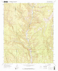
Editions of this 1961 Rosilla Peak Map
3 editions found
Other maps of this area

1889 · Santa Fe
USGS Topo · 1:125,000

1894 · Santa Fe
USGS Topo · 1:125,000

1953 · Glorieta
USGS Topo · 1:24,000

1953 · Mc Clure Reservoir
USGS Topo · 1:24,000

1953 · Aspen Basin
USGS Topo · 1:24,000

1954 · Santa Fe
USGS Topo · 1:250,000

1958 · Santa Fe
USGS Topo · 1:250,000

1961 · Honey Boy Ranch
USGS Topo · 1:24,000

1961 · Rosilla Peak
USGS Topo · 1:24,000
1961 · Pecos
USGS Topo · 1:24,000