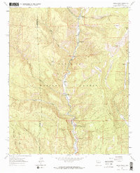
1961 Map of Rosilla Peak
USGS Topo · Published 1973About this map
The Pecos River carves a deep north-south corridor through the heart of the Santa Fe National Forest, serving as the primary anchor for human activity in this high-altitude landscape. During the late 1950s and early 1960s, this area functioned as a hub for both industry and recreation, evidenced by the presence of Terrero and its associated post office near the confluence with Holy Ghost Creek. The mapping of El Macho as a site suggests the transitory nature of early mountain settlements, while the Jones Mine tucked into the western ridges reflects the era's mineral prospecting. Recreational development is prominent along the canyon floor, with Camp La Salle, Field Tract Campground, and the Dalton Picnic Area clustered near the water. On the eastern heights, landmarks like Rosilla Peak and Viveash Mesa overlook a network of trails, including the Sawyer Trail, which connect high-country ranching outposts like Martin Ranch.
Find a feature on this map
32 named features on this map. Tap any name to fly to it.
Don’t see what you’re looking for? This feature index may not catch every label — zoom into the map to look around manually.
Map Details
Editions of this 1961 Rosilla Peak Map
3 editions found
Other maps of this area

1889 · Santa Fe
USGS Topo · 1:125,000

1894 · Santa Fe
USGS Topo · 1:125,000

1953 · Glorieta
USGS Topo · 1:24,000

1953 · Mc Clure Reservoir
USGS Topo · 1:24,000

1953 · Aspen Basin
USGS Topo · 1:24,000

1954 · Santa Fe
USGS Topo · 1:250,000

1958 · Santa Fe
USGS Topo · 1:250,000

1961 · Honey Boy Ranch
USGS Topo · 1:24,000

1961 · Rosilla Peak
USGS Topo · 1:24,000
1961 · Pecos
USGS Topo · 1:24,000