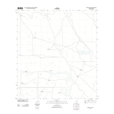
2013 Map of Rosita Lake
USGS Topo · Published 2013About this map
Rosita Lake anchors this coastal ranching landscape in Kenedy County, where water management is the primary driver of human footprint. The map reveals a specialized cattle-country infrastructure defined by a network of scattered windmills, each bearing a distinct name that often reflects local heritage or seasonal events. These landmarks, such as Chiltipin Windmill, El Florido Windmill, and the patriotically named Cuatro de Julio Windmill, provide essential water for livestock across a terrain marked by numerous small depressions and ephemeral water bodies. The lack of traditional town centers or dense road networks emphasizes the isolated, large-scale ranching operations characteristic of this region in the early 21st century. Researchers can use the positions of Mackin Windmill and Tres Esquinas Windmill to orient historical family landholdings and understand the logistical layout of these expansive South Texas properties.
Find a feature on this map
12 named features on this map. Tap any name to fly to it.
Don’t see what you’re looking for? This feature index may not catch every label — zoom into the map to look around manually.
Map Details
Editions of this 2013 Rosita Lake Map
This is the sole edition of this map. No revisions or reprints were ever made.
Other maps of this area

1921 · Tarida Ranch
USGS Topo · 1:62,500

1922 · La Sal Vieja
USGS Topo · 1:62,500

1923 · Armstrong
USGS Topo · 1:62,500

1923 · Saltillo Ranch
USGS Topo · 1:62,500

1953 · Brownsville
USGS Topo · 1:250,000

1956 · Saltillo Well
USGS Topo · 1:24,000

1956 · Rudolph
USGS Topo · 1:24,000
1956 · Los Amigos Windmill
USGS Topo · 1:24,000

1956 · Rosita Lake
USGS Topo · 1:24,000

1956 · San Perlita North
USGS Topo · 1:24,000