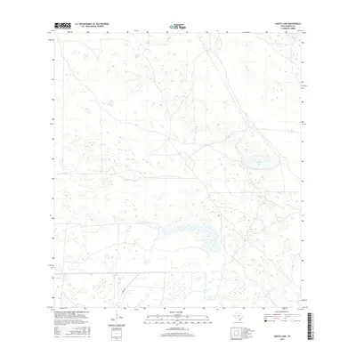
2016 Map of Rosita Lake
USGS Topo · Published 2016About this map
Rosita Lake lies at the heart of this coastal plains landscape in Kenedy County, surrounded by an intricate network of wetlands and ephemeral water bodies. This 2016 survey captures the sparse, ranch-dominated character of the South Texas brush country, where human imprints are primarily limited to the passage of H Yturria Rd. The terrain is defined by a distinct pattern of depressions and small basins that collect seasonal water, essential for local wildlife and cattle in this semi-arid environment. By documenting the exact placement of these water features and the primary ranch road, the map provides a contemporary record of land use and hydrology in one of the state's most privately held and least densely populated regions.
Find a feature on this map
2 named features on this map. Tap any name to fly to it.
Don’t see what you’re looking for? This feature index may not catch every label — zoom into the map to look around manually.
Map Details
Editions of this 2016 Rosita Lake Map
This is the sole edition of this map. No revisions or reprints were ever made.
Other maps of this area

1921 · Tarida Ranch
USGS Topo · 1:62,500

1922 · La Sal Vieja
USGS Topo · 1:62,500

1923 · Armstrong
USGS Topo · 1:62,500

1923 · Saltillo Ranch
USGS Topo · 1:62,500

1953 · Brownsville
USGS Topo · 1:250,000

1956 · Saltillo Well
USGS Topo · 1:24,000

1956 · Rudolph
USGS Topo · 1:24,000
1956 · Los Amigos Windmill
USGS Topo · 1:24,000

1956 · Rosita Lake
USGS Topo · 1:24,000

1956 · San Perlita North
USGS Topo · 1:24,000