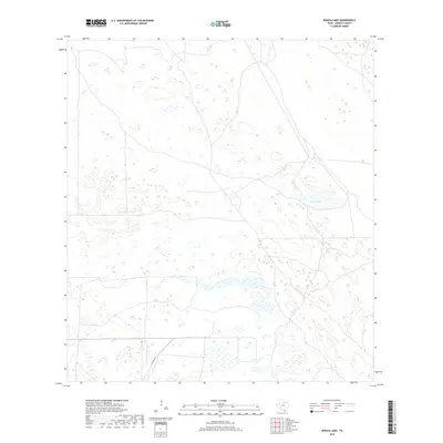
2019 Map of Rosita Lake
USGS Topo · Published 2019About this map
Rosita Lake and the surrounding coastal plains of Kenedy County define this quiet landscape in South Texas. This region is characterized by extensive wetlands and complex drainage patterns, visible through the numerous depressions and ephemeral water bodies across the terrain. The presence of H Yturria Rd provides the primary access through this sparsely populated territory, which is part of a larger network of private ranchlands. The topography is relatively flat, with subtle contour intervals revealing the intricate nature of the coastal basin's hydrology. For those studying the geography of the South Texas brush country, this map provides clear detail of the natural surface features and the minimal human infrastructure that has shaped the area.
Find a feature on this map
2 named features on this map. Tap any name to fly to it.
Don’t see what you’re looking for? This feature index may not catch every label — zoom into the map to look around manually.
Map Details
Editions of this 2019 Rosita Lake Map
This is the sole edition of this map. No revisions or reprints were ever made.
Other maps of this area

1921 · Tarida Ranch
USGS Topo · 1:62,500

1922 · La Sal Vieja
USGS Topo · 1:62,500

1923 · Armstrong
USGS Topo · 1:62,500

1923 · Saltillo Ranch
USGS Topo · 1:62,500

1953 · Brownsville
USGS Topo · 1:250,000

1956 · Saltillo Well
USGS Topo · 1:24,000

1956 · Rudolph
USGS Topo · 1:24,000
1956 · Los Amigos Windmill
USGS Topo · 1:24,000

1956 · Rosita Lake
USGS Topo · 1:24,000

1956 · San Perlita North
USGS Topo · 1:24,000