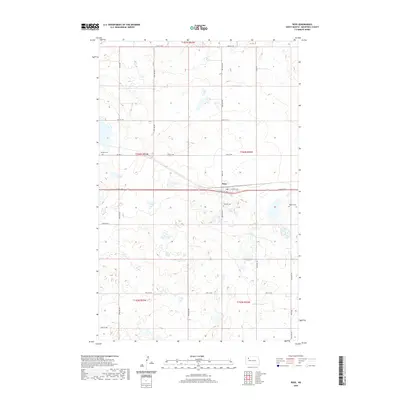
2020 Map of Ross
USGS Topo · Published 2020About this map
Ross occupies the central portion of this Mountrail County landscape, where the intersection of Central Ave and Co Hwy 2 marks the local social and economic hub. The surrounding prairie is defined by a rigorous section-line road grid, including 66th St NW and 62nd St NW, which structure the rural agricultural environment. A notable aspect of the local cultural history is the presence of three distinct burial grounds: Manitou Cem to the west, and Rosehill Cem and Moslem Cem situated near the town site. The latter is a significant marker of North Dakota's diverse heritage, specifically reflecting the early 20th-century history of Syrian-Lebanese settlers in the region. This land-survey pattern highlights a landscape where traditional township boundaries like t156n r92w continue to dictate property and infrastructure layout.
Find a feature on this map
25 named features on this map. Tap any name to fly to it.
Don’t see what you’re looking for? This feature index may not catch every label — zoom into the map to look around manually.
Map Details
Editions of this 2020 Ross Map
This is the sole edition of this map. No revisions or reprints were ever made.
Other maps of this area

1953 · Williston
USGS Topo · 1:250,000

1957 · Williston
USGS Topo · 1:250,000

1969 · Ross NW
USGS Topo · 1:24,000

1969 · Stanley
USGS Topo · 1:24,000

1981 · Robinson Lake
USGS Topo · 1:24,000

1981 · Ross
USGS Topo · 1:24,000

1981 · Manitou
USGS Topo · 1:24,000

1981 · Lostwood
USGS Topo · 1:24,000
1981 · Rat Lake
USGS Topo · 1:24,000
1981 · Cottonwood Lake
USGS Topo · 1:24,000