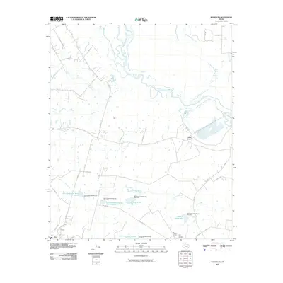
2010 Map of Rosser SW
USGS Topo · Published 2010About this map
The meandering Trinity River defines the northern landscape of this region, shaping a network of tributaries including Village Creek, Walker Creek, and Bois d'Arc Creek. In the southwestern corner, the settlement of Rice sits near the Rice Oil Field, indicating the local importance of the petroleum industry. The area is characterized by a significant water management infrastructure, evidenced by a series of Soil Conservation Service sites, including Soil Conservation Service Site 1 Reservoir and Reservoir Number Five. Genealogy researchers will find several points of interest, notably the Rice Cemetery, Old Chatfield Cemetery, and New Chatfield Cemetery located in the southern half of the quadrangle. Further north, Valley Farms serves as a named landmark among the rural roads and agricultural drainage basins that feed into the Trinity.
Find a feature on this map
50 named features on this map. Tap any name to fly to it.
Don’t see what you’re looking for? This feature index may not catch every label — zoom into the map to look around manually.
Map Details
Editions of this 2010 Rosser SW Map
This is the sole edition of this map. No revisions or reprints were ever made.
Other maps of this area

1954 · Dallas
USGS Topo · 1:250,000

1956 · Ennis
USGS Topo · 1:62,500

1958 · Dallas
USGS Topo · 1:250,000

1960 · Grays Prairie
USGS Topo · 1:24,000

1961 · Chatfield
USGS Topo · 1:24,000

1962 · Bazette
USGS Topo · 1:24,000

1962 · Emhouse
USGS Topo · 1:24,000

1962 · Ennis East
USGS Topo · 1:24,000

1962 · Rosser SW
USGS Topo · 1:24,000
1962 · Styx
USGS Topo · 1:24,000