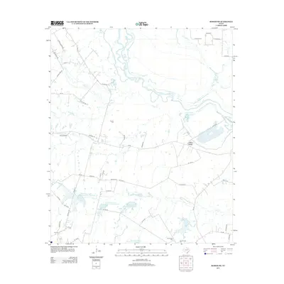
2012 Map of Rosser SW
USGS Topo · Published 2012About this map
The Trinity River meanders through the northern section of this Navarro County landscape, defining a terrain shaped by agricultural development and energy extraction. Evidence of the local petroleum industry is centered at the Rice Oil Field, while the southern reaches show a complex network of water management through several Soil Conservation Service reservoirs, including Soil Conservation Service Site 1 Reservoir and Reservoir Number Five. This 2012 survey documents the rural character of the area near Rice Cem, where small agricultural operations like Valley Farms and Clubhouse Farm are interspersed with tributary systems such as Cottonwood Cr and Village Cr. The map also preserves the location of regional landmarks like Skylark Airport and provides a detailed record of local burial grounds, including both the Old Chatfield Cem and New Chatfield Cem.
Find a feature on this map
57 named features on this map. Tap any name to fly to it.
Don’t see what you’re looking for? This feature index may not catch every label — zoom into the map to look around manually.
Map Details
Editions of this 2012 Rosser SW Map
This is the sole edition of this map. No revisions or reprints were ever made.
Other maps of this area

1954 · Dallas
USGS Topo · 1:250,000

1956 · Ennis
USGS Topo · 1:62,500

1958 · Dallas
USGS Topo · 1:250,000

1960 · Grays Prairie
USGS Topo · 1:24,000

1961 · Chatfield
USGS Topo · 1:24,000

1962 · Bazette
USGS Topo · 1:24,000

1962 · Emhouse
USGS Topo · 1:24,000

1962 · Ennis East
USGS Topo · 1:24,000

1962 · Rosser SW
USGS Topo · 1:24,000
1962 · Styx
USGS Topo · 1:24,000