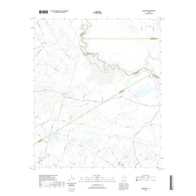
2019 Map of Rosser SW
USGS Topo · Published 2019About this map
The town of Rice sits at the southwestern edge of this landscape, where the blackland prairies of Navarro County meet a complex network of creeks and man-made water features. The area is defined by the winding course of the Trinity River, which serves as a natural boundary between Ellis, Kaufman, Henderson, and Navarro counties. This 2019 survey documents a landscape heavily managed for water, featuring significant impoundments like Reservoir Number One, Reservoir Number Two, and Reservoir Number Five north of the Chatfield area.
Find a feature on this map
59 named features on this map. Tap any name to fly to it.
Don’t see what you’re looking for? This feature index may not catch every label — zoom into the map to look around manually.
Map Details
Editions of this 2019 Rosser SW Map
This is the sole edition of this map. No revisions or reprints were ever made.
Other maps of this area

1954 · Dallas
USGS Topo · 1:250,000

1956 · Ennis
USGS Topo · 1:62,500

1958 · Dallas
USGS Topo · 1:250,000

1960 · Grays Prairie
USGS Topo · 1:24,000

1961 · Chatfield
USGS Topo · 1:24,000

1962 · Bazette
USGS Topo · 1:24,000

1962 · Emhouse
USGS Topo · 1:24,000

1962 · Ennis East
USGS Topo · 1:24,000

1962 · Rosser SW
USGS Topo · 1:24,000
1962 · Styx
USGS Topo · 1:24,000