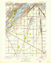
1951 Map of Rossford
USGS Topo · Published 1953About this map
The Maumee River serves as the industrial and geographic spine of this Wood County landscape, where the multi-channel waterway is dotted by islands such as Delaware Island, Grassy Island, and Clark Island. On the northern banks, significant institutional presence is visible through the Toledo State Hospital, the Maumee Valley Hospital, and the County Infirmary, while the adjacent Zoological Gardens indicates the area's recreational development. South of the river, the massive Rossford Ordnance Depot and several sprawling rail yards, including Stanley Yard and Harris Yard, underscore the region's importance as a mid-century transportation and military logistics hub. Smaller rural communities like Lime City, Moline, and Stony Ridge are interconnected by a dense grid of local roads and the tracks of the New York Central Railroad, illustrating the transition from the industrial riverfront to the agricultural interior of Wood County.
Find a feature on this map
88 named features on this map. Tap any name to fly to it.
Don’t see what you’re looking for? This feature index may not catch every label — zoom into the map to look around manually.
Map Details
Editions of this 1951 Rossford Map
This is the sole edition of this map. No revisions or reprints were ever made.
Other maps of this area

1900 · Maumee Bay
USGS Topo · 1:62,500

1900 · Toledo
USGS Topo · 1:62,500

1901 · Bowling Green
USGS Topo · 1:62,500

1901 · Elmore
USGS Topo · 1:62,500

1903 · Bowling Green
USGS Topo · 1:62,500

1903 · Elmore
USGS Topo · 1:62,500

1934 · Point Place
USGS Topo · 1:24,000

1934 · Rossford
USGS Topo · 1:24,000

1935 · Walbridge
USGS Topo · 1:24,000

1935 · Maumee
USGS Topo · 1:24,000