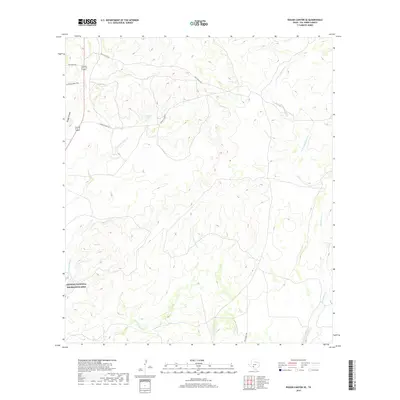
2019 Map of Rough Canyon SE
USGS Topo · Published 2019About this map
Amistad National Recreation Area occupies the southwestern corner of this West Texas landscape, where the arid terrain is defined by complex drainage systems and isolated ranching routes. The eponymous Rough Canyon feeds into a network of waterways including San Pedro Cr and its northern branch, N Fork San Pedro Cr, while the eastern portion of the sheet is dominated by Sycamore Creek and the W Fork Sycamore Cr. The land use is characterized by large private holdings and remote access, indicated by ranch-specific infrastructure such as Gillis Ranch Rd, Lewis Ranch Rd, and Gurley Mcbee Rd. A small upland catchment known as Moody Lake provides a rare point of named surface water amidst the rugged draws and ridges. These roads and canyons illustrate the enduring rural character of Val Verde County, maintaining a landscape focused on conservation and traditional ranching operations.
Find a feature on this map
13 named features on this map. Tap any name to fly to it.
Don’t see what you’re looking for? This feature index may not catch every label — zoom into the map to look around manually.
Map Details
Editions of this 2019 Rough Canyon SE Map
This is the sole edition of this map. No revisions or reprints were ever made.
Other maps of this area

1941 · Standart
USGS Topo · 1:62,500

1943 · Standart
USGS Topo · 1:62,500

1943 · Del Rio
USGS Topo · 1:62,500

1944 · Flat Rock
USGS Topo · 1:62,500

1944 · Devils Lake
USGS Topo · 1:62,500

1958 · Del Rio
USGS Topo · 1:250,000

1964 · Del Rio
USGS Topo · 1:250,000

1972 · Miers Ranch
USGS Topo · 1:24,000

1972 · Rough Canyon SE
USGS Topo · 1:24,000
1972 · Del Rio NW
USGS Topo · 1:24,000