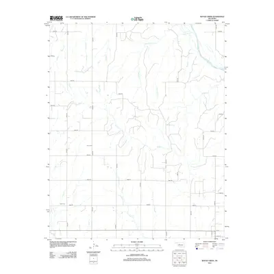
2012 Map of Rough Creek
USGS Topo · Published 2012About this map
The Canadian River cuts across the northeastern corner of this western Oklahoma landscape, defining a drainage network that includes Yellow Bull Cr, One Horse Cr, and the central Rough Creek from which the quadrangle takes its name. The terrain is characterized by a precise grid of rural roads, such as e0840 RD and n2330 RD, which serve a scattered agricultural community. For family historians, the map provides exact locations for local burial grounds, including Bethel Cem in the southwest and Forney Cem near the center. These small landmarks, along with numerous named tributaries like Eggleston Cr and Little Deer Cr, offer a detailed view of the Custer County countryside as it appeared in the early 21st century, just north of the section lines leading into Thomas.
Find a feature on this map
36 named features on this map. Tap any name to fly to it.
Don’t see what you’re looking for? This feature index may not catch every label — zoom into the map to look around manually.
Map Details
Editions of this 2012 Rough Creek Map
This is the sole edition of this map. No revisions or reprints were ever made.
Other maps of this area

1955 · Clinton
USGS Topo · 1:250,000

1957 · Clinton
USGS Topo · 1:250,000

1957 · Clinton
USGS Topo · 1:62,500

1962 · Putnam
USGS Topo · 1:62,500

1964 · Oakwood
USGS Topo · 1:62,500

1964 · Weatherford
USGS Topo · 1:62,500

1976 · Clinton NW
USGS Topo · 1:24,000

1976 · Clinton NE
USGS Topo · 1:24,000
1983 · Custer City
USGS Topo · 1:24,000
1983 · Clinton NE
USGS Topo · 1:24,000