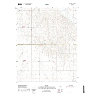
2018 Map of Rough Creek
USGS Topo · Published 2018About this map
Thomas anchors the southeastern corner of this Oklahoma landscape, which straddles the boundary between Dewey Co and Custer Co. The terrain is deeply incised by a dense network of creek systems, including Yellow Bull Cr, One Horse Cr, and Rough Cr, all trending toward the Canadian River in the northeast. This topographical complexity suggests a history of erosion and local drainage that shaped the development of early homesteads and roads. For genealogists, the map identifies specific burial sites such as Bethel Cem and Forney Cem, providing primary evidence for early community centers in this rural district. The grid of section lines and local roads like N2320 Rd and E0850 Rd reflects the enduring influence of the Public Land Survey System on the modern Western Oklahoma layout.
Find a feature on this map
38 named features on this map. Tap any name to fly to it.
Don’t see what you’re looking for? This feature index may not catch every label — zoom into the map to look around manually.
Map Details
Editions of this 2018 Rough Creek Map
This is the sole edition of this map. No revisions or reprints were ever made.
Other maps of this area

1955 · Clinton
USGS Topo · 1:250,000

1957 · Clinton
USGS Topo · 1:250,000

1957 · Clinton
USGS Topo · 1:62,500

1962 · Putnam
USGS Topo · 1:62,500

1964 · Oakwood
USGS Topo · 1:62,500

1964 · Weatherford
USGS Topo · 1:62,500

1976 · Clinton NW
USGS Topo · 1:24,000

1976 · Clinton NE
USGS Topo · 1:24,000
1983 · Custer City
USGS Topo · 1:24,000
1983 · Clinton NE
USGS Topo · 1:24,000