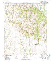
1985 Map of Rough Creek
USGS Topo · Published 1985About this map
The Canadian River cuts through the northeast corner of this landscape, marking a transition from the river valley to the dissected uplands of western Oklahoma. An extensive Oil and Gas Field dominates the central terrain, characterized by a dense network of Gas Wells and Oil Wells scattered across the ridges between drainages like Rough Creek and Yellow Bull Creek. This industrial footprint is overlaid on a rural township structure, where the borders of Dewey and Custer counties intersect.
Find a feature on this map
26 named features on this map. Tap any name to fly to it.
Don’t see what you’re looking for? This feature index may not catch every label — zoom into the map to look around manually.
Map Details
Editions of this 1985 Rough Creek Map
This is the sole edition of this map. No revisions or reprints were ever made.
Other maps of this area

1955 · Clinton
USGS Topo · 1:250,000

1957 · Clinton
USGS Topo · 1:250,000

1957 · Clinton
USGS Topo · 1:62,500

1962 · Putnam
USGS Topo · 1:62,500

1964 · Oakwood
USGS Topo · 1:62,500

1964 · Weatherford
USGS Topo · 1:62,500

1976 · Clinton NW
USGS Topo · 1:24,000

1976 · Clinton NE
USGS Topo · 1:24,000
1983 · Custer City
USGS Topo · 1:24,000
1983 · Clinton NE
USGS Topo · 1:24,000